Description
The 1:50 000 Map Series provides clear and accurate portrayal of topographic information, with symbols and map content giving enhanced depiction of buildings, hill shading and a simplified classification of vegetation.
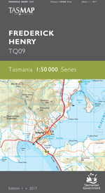
This map is centred on the picturesque town of Kettering, the ferry departure point for Bruny Island. The Channel Highway traverses southwards through the towns of Margate, Snug, Kettering, Woodbridge, Middleton and Gordon where lush pastures, orchards, vineyards and bushland roll down to the water’s edge of D’Entrecasteaux Channel. The hamlet of Cygnet, popular amongst artists and musicians, is further along the highway. In the west of the map, Huonville is the commercial business hub of the Huon Valley. Located further downstream on the banks of the tranquil Huon River is Franklin, known for its quaint village streetscapes and traditional wooden boat building. This is an ideal map for boating and fishing enthusiasts, or for walkers exploring the numerous nature recreation and conservation areas.
- Edition: 1
- Production Year: 2017
- Datum: Geocentric Datum of Australia 1994 (GDA94)