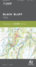
Description
The design of the 1:50 000 Map Series provides clear and accurate portrayal of topographic information, with symbols and map content giving enhanced depiction of buildings, hill shading and a simplified classification of vegetation.
The Princess Range lies parallel to the lower Franklin River in Tasmania’s rugged Franklin – Gordon Wild Rivers National Park which is in the heart of the Tasmanian Wilderness World Heritage Area. This ancient land of deep gorges, ancient forests, caves and rivers was nearly flooded by hyrdo-electric scheme in the 1980s but was saved by a High Court decision. The Franklin River is now a mecca for rafters.
- Edition: 1
- Production Year: 2021
- Datum: Geocentric Datum of Australia 2020 (GDA2020)