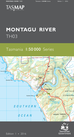
Description
The design of the 1:50 000 Map Series provides a clear and accurate portrayal of topographic information, with symbols and map content giving enhanced depiction of buildings, hill shading and a simplified classification of vegetation.
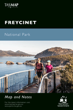
Mount William National Park is a pristine paradise tucked away on the north east coast of Tasmania. The windswept coastline features rocky outcrops marked with bright orange lichen and seemingly endless stretches of powder white sand that squeaks beneath your feet – all set against a backdrop of crystal clear turquoise water. The coastal heathlands of the park are home to the Xanthorrhoea plant; a skirt-like grass bush with a singular tall spike spire. A diverse array of terrestrial, freshwater, estuarine, coastal and marine habitats, each contain important flora and fauna species and ecosystems. Mount William National Park is perfect for walking, fishing, swimming or kicking back at your beachside campsite doing nothing at all. The park is home to an abundance of Tasmanian marsupials and, as you explore, you may spot kangaroos, wombats, wallabies or echidnas. wukalina/Mount William sits at 216m above sea level. From the summit enjoy panoramic views of the coast and, on a clear day, all the way to the Furneaux Islands in Bass Strait. The Musselroe Bay Conservation Area is popular with birdwatchers while the camping area offers a number of sites. The main attraction in the area is the Eddystone Lighthouse which is located 13 km north of Ansons Bay. The lighthouse was built from pink granite in 1889 and stands 42 metres above sea level.
- Edition: 1
- Production Year: 2020
- Datum: Geocentric Datum of Australia 2020 (GDA2020)