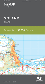
Description
The design of the 1:50 000 Map Series provides a clear and accurate portrayal of topographic information, with symbols and map content giving enhanced depiction of buildings, hill shading and a simplified classification of vegetation.
This map features a wide range of environments in the far northwest of Tasmania. The northern portion of the map includes long sandy beaches, numerous bays and inlets. The fishing town of Stanley, with The Nut as a scenic background, and the regional centre of Smithton are shown. Smithton is supported by aquaculture, along with a range of local land produce including crop, dairy and beef farming and timber production, while Stanley is a hotspot for tourists. Additionally, the map area comprises of cool temperate rainforests and numerous significant rivers including Arthur, Black and Duck rivers.
- Edition: 1
- Production Year: 2020
- Datum: Geocentric Datum of Australia 2020 (GDA2020)